July 5, 2019 3326 Washington Street, Jamaica Plain: The Turnpike School (Part 2)
Jenny Nathans is a public health professional, a burgeoning preservationist, and a resident of Jamaica Plain. In this blog post, she tells the fascinating story of a surviving example of the purpose-built school house at 3326 Washington Street, Jamaica Plain. The structure is central to the discussion about development of the property. Thank you to Jenny for compiling such a comprehensive history of this historic structure.
Set back in a paved lot beside Washington Street is an understated building that played an important role in the development of Jamaica Plain and the evolution of the Boston school system. 3326 Washington Street is a former primary school that is being eyed for development and possible demolition. The following history illustrates that it is a significant structure that is worthy of being preserved. This is part 2 of her article, which outlines the architectural significance of the building. See part 1 here.
Architecture
In addition to its significant role in the evolution of the neighborhood of Jamaica Plain, the Turnpike School building holds architectural significance for the City of Boston. A 1980’s Boston Landmarks Commission survey stated that the “structure is significant as a rare example of a mid 19th century Boston-area primary school…apparently this unpretentious building represents a standard West Roxbury school house type.”
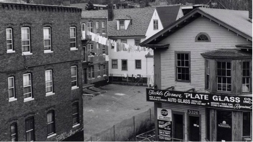
The Landmarks Commission survey explained that the framed building is a “rectangular plan Italianate school house, constructed of wood, rises 2-stories to gable with bracketed return eaves and lunette attic window. [It has a] 2-bay main facade…exhibit[ing a] two narrow entrance and 2-story octagonal bay. Three windows appear on [a] side wall, contain[ing] 6/6 wood sash.”
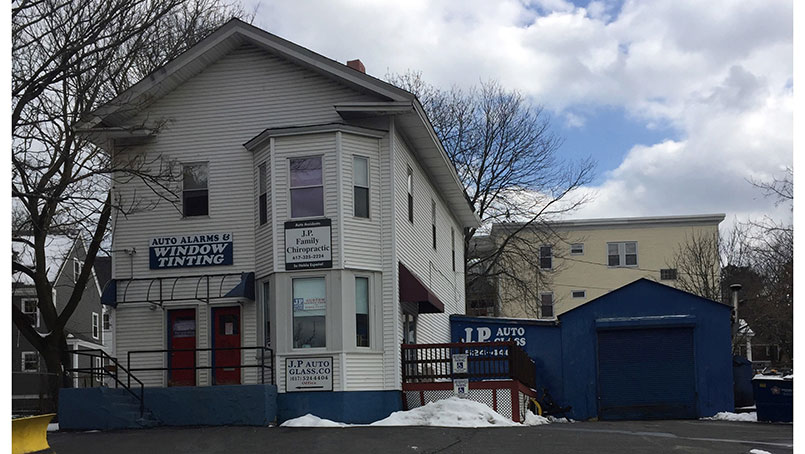
A photo taken in 1985 illustrates what the building looked like prior to the installation of its current vinyl siding. This is possibly how the structure appeared when the building functioned as a school, and later as a dwelling. Currently, on the rear side of the building, a significant portion of the clapboard siding is exposed, as is a part of the eave. This raises the strong possibility that more original architectural details still exist, hidden just behind the vinyl.

School becomes a Dwelling and Glass Service Business
In October of 1892, the City of Boston sold 3326 Washington Street to real-estate developer Patrick Meehan, at which time the school was closed and the building converted to a dwelling. The timing of the sale of the schoolhouse to Meehan appears to be related to the opening of the Margaret Fuller School at 25 Glen Road. The relatively larger, brick Margaret Fuller school opened in April of 1892, very close to the site of the old Washington Street (Turnpike) School. A larger primary school would have been necessary at that time for the densely populated neighborhood. It is interesting to note that once the Washington Street School closed, its two teachers, E. Augusta Randall and Ellen E. Foster, began working as teachers at Margaret Fuller.
As a testament to the building’s versatility, in 1958, the old schoolhouse was repurposed for another new use, this time as a commercial glass service business. The building functioned in this capacity until this year when the building was purchased by developers.
The Turnpike Schoolhouse tells the story of a major period of transition and growth for Jamaica Plain. It is also the oldest schoolhouse structure remaining in the JP/Rox corridor, if not the oldest building in the Egleston Square area, and one of the last vestiges of construction along the Norfolk and Bristol Turnpike. Unfortunately, this historic structure is now threatened with demolition. Recognizing both the historic significance of the site, and the need for affordable housing in Boston, it’s crucial that the developers choose a creative design for the property that combines preservation of the Schoolhouse with affordability and meets the Plan: JP/Rox goal of preserving the existing form and character of the neighborhood.
Sources
- Annual Reports of the School Committee of the Town of West Roxbury
- Boston Inspectional Services
- Boston Landmarks Commission Survey
- Digital Commonwealth
- Manuals of the Public Schools of the City of Boston
Maps
- Norfolk County Registry of Deeds
- Suffolk County Registry of Deeds
- Van Hoffman, A. (1994) Local Attachments: The Making of an American Urban Neighborhood, 1850 to 1920. Baltimore, MD: The John Hopkins University Press.
Maps
- 1858: archive.org/details/1858_Map_of_Jamaica_Plain
- 1874: ia800204.us.archive.org/16/items/1874_Hopkins_Map_of_Jamaica_Plain/plate.F.1874.jpg
- 1884: ia802705.us.archive.org/0/items/G.W._Bromley_1884_Map_West_Roxbury_Jamaica_Plain/B.jpg
- 1891: https://collections.leventhalmap.org/search/commonwealth:x633fc34d
- 1896: ia802608.us.archive.org/0/items/1896_Bromley_Map_of_Jamaica_Plain/plate1.1896.jpg
- 1924: https://www.loc.gov/resource/g3764bm.gla00102/?sp=6&r=0.078,0.184,0.208,0.086,0


