


06 May 2019 Eighteenth Century GPS: Milestones and Way Markers in Boston
We feature a guest post here from Earl Taylor, President of the Dorchester Historical Society and the owner/creator of content for the Dorchester Athenaeum website (www.dorchesteratheneum.org). He shares with us research he has been compiling on Boston’s many extant mile markers from the 18th and 19th centuries.
It seems that everywhere I look there are stones. New England has its well-deserved reputation for rocky ground. Our cemeteries are full of stones erected to help us remember our loved ones. My attention, though, has recently been drawn to carved stones that come from a different path in our cultural heritage: milestones.
In 1707 Samuel Sewall set up 1-mile and 2-mile markers in Boston along the road to Roxbury, measuring from the Town House, which stood approximately where the Old State House is now located. In those years there was only one road out of Boston due to the narrowness of the Neck, and it led to Eliot Square in Roxbury, where roads diverged in various directions. In the remaining years of the first half of the 18th century, other stone markers appeared along these routes. The men who were responsible for their erection were motivated by public spirit and possibly by a desire to heighten their own reputations.
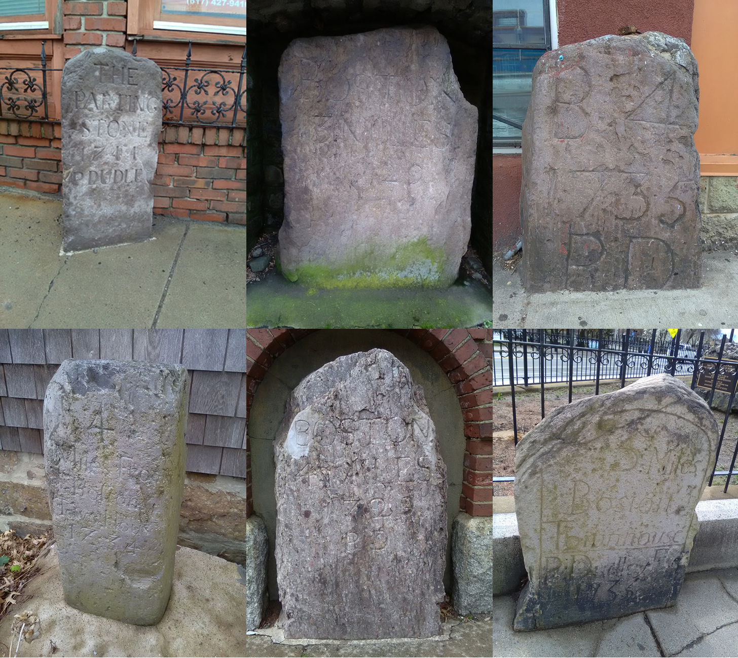
In 1729 Paul Dudley placed stone markers on the road to Cambridge at the 3-mile and 4-mile points in Roxbury, the 5-mile point in Brookline, and the 6 and 7-mile points in the Allston section of Brighton. The three-mile stone has been lost. Dudley was Chief Justice of the Massachusetts Supreme Judicial Court and lived in Roxbury like his father and grandfather, who was a colonial Governor of Massachusetts. That same year he set up the 3, 4, 5, 6 and 7-mile stones along Centre Street stretching from Roxbury through Jamaica Plain, and all these are still standing. In 1735 he set up 3 and 4-mile markers on the Upper Road (Warren Street) from Roxbury to Dorchester. The 4-mile marker still stands, though moved from 473 Warren Street to 471 Blue Hill Avenue. Then in 1744 he set up the Parting Stone at Eliot Square, which is not itself a mile-marker but a way marker to direct the traveler to the proper road. Of the known 14 mile-markers that are now extant along our streets within the City of Boston, nine of them were put in place by Dudley.
In 1734 Jonathan Belcher placed milestones on the Lower Road through Roxbury and Dorchester (Dudley to Hancock to Adams Streets) at the 3, 4, 5, 6-mile distances and a 7-mile marker in Milton. Two of the Dorchester stones remain, one has been moved to the James Blake House on Columbia Road, and the other is in the wall of Dorchester Park on Adams Street. Jonathan Belcher was a colonial governor of New Hampshire (1729-1741), Massachusetts (1730-1741) and New Jersey (1747-1757). Belcher had a country home in Milton.
1823 John McLean started a project to place mile markers along the Brush Hill Turnpike. He died before all the stones were in place, and his business partner Isaac Davenport completed the project. The McLean Hospital was named for John, who was a substantial merchant in Boston. Only one stone remains from McLean’s 5, 6, 7-mile markers in Dorchester/Mattapan, the 6-milemarker at 1261-1269 Blue Hill Avenue.
A six-mile marker, of unknown origin from the Upper Road (Washington Street), has been moved to the James Blake House, and a 1-mile-to-Boston marker for the Worcester Turnpike is incorporated into a stone wall opposite 1425 Tremont Street.
There are also some boundary stones still extant showing the boundary between towns, but that is a topic for another day.
Earl Taylor received the K. Julie McCarthy Community Spirit Award from Preservation Massachusetts in 2018