


25 Feb 2016 Researching the Agricultural History of the Fowler Clark Epstein Farm
Rita Walsh, Senior Preservation Planner, with VHB is assisting HBI with state and federal historic tax credit applications to support the rehabilitation of the Fowler Clark Epstein Farm property for its new uses. She is also preparing a nomination of the property to the National Register of Historic Places. Although the property is already a Boston Landmark, the property must be officially listed in the National Register to receive the federal historic tax credits.
The 2005 Boston Landmarks Commission study report for theFowler Clark Epstein farm (which is the document that presents the reasons for the property’s significance and eligibility as a local landmark) contains an incredible amount of detail about the farm?s ownership history. The house and barn were part of an 11.25-acre parcel bounded by Norfolk Street and Blue Hill Avenue (originally known as Brush Hill Turnpike) that remained the same size from 1806 until 1895, when it was finally subdivided for building parcels by James Clark and his mother, Mary.
Attempting to find out more about the agricultural history of the property for the National Register nomination led me to several fascinating sources. Although I knew Henry Clark (1791-1872), who bought the parcel in 1837 with his wife Mary, was a farmer, I did not know what kind of farming he did and understood he only owned this parcel, a small size for a 19th century farm but not out of the question.
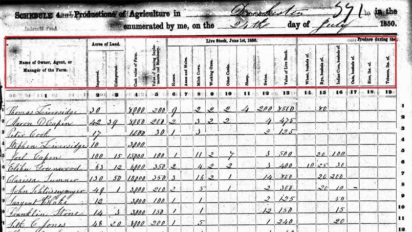
One source was the agricultural schedule of the U.S. Census. Only taken in 1850, 1860, 1870 and 1880, the schedule lists the names of farmers, their crops and the quantities harvested, the type of livestock they owned, and the number of acres they farmed, both improved and unimproved. Although I could only find Henry Clark’s name in the 1850 and 1860 schedules, it was nonetheless great information. Clark grew Indian corn, Irish potatoes, and hay, and had several milk cows, similar to many of his neighbors. In these two schedules, Henry Clark reported he had 25-26 acres of both improved and unimproved land, which immediately led me to question where those extra acres in Dorchester were located. Was the additional land contiguous or was it, perhaps, a separate woodlot or pasture?
I assumed the additional land was contiguous, based on my examination of maps from 1850, 1853 and 1874. It appeared that perhaps Henry Clark owned a large amount of land to the south of his 11.25 acre parcel. The 1874 map showed two separate parcels to the south that coincidentally totaled 15 acres, so I thought I would check deed records at the Norfolk County Registry of Deeds (Dorchester was in this county until it was annexed to Boston in 1870) to confirm. After several hours spent researching what I thought would be a straightforward story, I could only conclude that Henry Clark never owned the land to the south along Norfolk Street, but that he owned several small parcels (most only an acre in size) further south on Norfolk Street, closer to the village of Mattapan.
It was Earl Taylor, President of the Dorchester HistoricalSociety, who reminded me about the 19th century tax records that noted the value of land and buildings for Dorchester residents. The records from the 1850s and 1860s provided a breakdown of the parcels and buildings Henry Clark owned, which corroborated the acreage in the 1850 and 1860 agricultural schedules. The tax records indicated his home parcel of 11.25 acres was occasionally used for pasture and that he owned over 9 acres of woodland, in addition to some smaller parcels. By 1869, Henry only owned the parcel his home was part of, possibly revealing his efforts to take it easier as he was 78 years old!