


June 24, 2019 3326 Washington Street, Jamaica Plain: The Turnpike School (Part 1)
Jenny Nathans is a public health professional, a burgeoning preservationist, and a resident of Jamaica Plain. In this blog post, she tells the fascinating story of a surviving example of the purpose-built school house at 3326 Washington Street, Jamaica Plain. The structure is central to the discussion about development of the property. Thank you to Jenny for compiling such a comprehensive history of this historic structure.
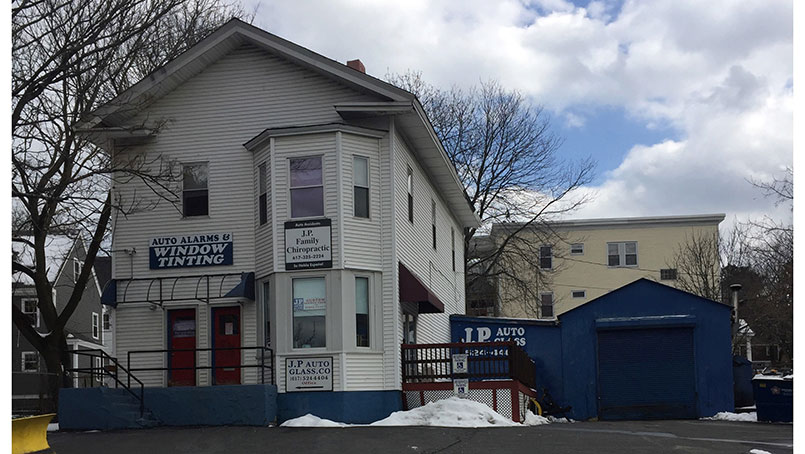
Set back in a paved lot beside Washington Street is an understated building that played an important role in the development of Jamaica Plain and the evolution of the Boston school system. 3326 Washington Street is a former primary school that is being eyed for development and possible demolition. The following history illustrates that it is a significant structure that is worthy of being preserved.
The Founding of the Turnpike School
On August 21, 1849, Reuben A. Lamb sold to the City of Roxbury 12,303 square feet of land located at the Dedham Turnpike (now Washington Street) and Woodside Avenue. This land only remained in Roxbury’s possession until 1851, the year that West Roxbury – and by extension, Jamaica Plain- seceded from Roxbury, and all City property transferred to the new town.
The following year, the Town of West Roxbury published its first Annual Report of the School Committee of the Town of West Roxbury. The Annual Report described a new primary school in the neighborhood called “No. 3, on the Turnpike.” From a study of maps, building permits, and school reports, we know that this schoolhouse is the existing building at 3326 Washington Street in Jamaica Plain, the former location of JP Auto Glass.
“No 3., on the Turnpike, nearly opposite Green Street, kept by Miss Jordan, has 41 pupils, viz: 20 girls and 21 boys. This house is new, and answers the object for which it was designed. It has two stories, one only of which is occupied, leaving a vacant room, which will, however, soon be wanted for the fast growing population in its vicinity.”
The statement that “this house is new” suggests that the school was built around 1851. Remarkably, this description also provides us with a location of the building, establishes that it was a co-ed institution, and explains why a school with only one teacher was built as a two-story structure. The school employed one teacher during the 1851-1852 school year, Sarah J. Jordan, and would continue to operate with one teacher through at least 1872. By 1875, students were taught by E. Augusta Randall and Jennie E. Eaton, indicating that the second floor of the schoolhouse was finally being utilized.
The Turnpike School operated between 1851 and 1892 – its life as an educational institution extending well after West Roxbury’s annexation to Boston, and thus playing a role in the evolution and history of the Boston public school system. The name that the primary school was referred to throughout the decades would change depending on the number of primary schools in Jamaica Plain and the evolving name of the road that ran past its front door: No. 3 Turnpike; No. 2 Turnpike; No. 2 Shawmut Avenue; No. 3 Shawmut Avenue; Washington Street School; and Washington Street School, Near Green Street.
As explained in one of the Annual Reports, “The schoolhouses [were] located with reference to the convenience of the various subdivisions of the town, for Primary School purposes.” Based on the locations of the other schools in 1852, (Thomas Street in Jamaica Plain, Forest Hills, Roslindale Village, and Spring Street near Dedham), it is clear that the No. 3, Turnpike school was the only primary school that served the Washington Street/Green Street area of Jamaica Plain after the neighborhood’s separation from Roxbury.
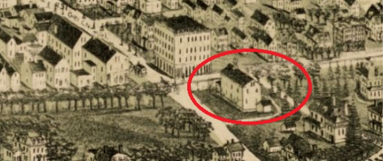
Close up of 1891 Bird’s Eye View map showing 3326 Washington Street
Historic maps and atlases illustrate that a school was indeed located at the corner of Washington and Woodside Avenue, opposite from Green Street, during the 19th century, and that it remained a public school after West Roxbury was annexed to Boston. A bird’s eye view map from 1891 contains a detailed drawing of the schoolhouse building that is currently at that site.
The school’s location near the Stony Brook and the commercial and industrial thoroughfare of Green Street was strategic. According to a 1980’s Boston Landmarks Commission survey of the site, the school was constructed for the children of the local Stony Brook Valley workers – individuals employed in places such as tanneries, carriage factories, breweries, and dye houses.
During its first school year (1851-1852), the new town of West Roxbury had two grammar schools and seven primary schools, each subject to the authority of the Town Committee. All West Roxbury primary schools were co-ed, with a student-to-teacher ratio averaging more than 40:1. Despite West Roxbury’s intent to retain its rural quality, improvements in public transportation, immigration, and the desire of city workers to live in the countryside led to a 170% growth in Jamaica Plain’s population between 1840 and 1850, and 497% by 1975, transforming Jamaica Plain from a rural enclave to a suburb. This also led to the overcrowding of classrooms, including the classroom at the Turnpike School. Overcrowding would prove to be a problem throughout West Roxbury’s life as a municipality. The school committee’s report in 1871 highlighted this issue:
“Within the past two years, there has been a large growth in that neighborhood, and Primaries Nos. 1, 2, 3, and 4 cannot accommodate all the pupils now in those districts. Nos. 3 and 4 are especially crowded, while Nos. 1 and 2 have as many as ought to be there.”
Stay tuned for Part 2!
Sources
- Annual Reports of the School Committee of the Town of West Roxbury
- Boston Inspectional Services
- Boston Landmarks Commission Survey
- Digital Commonwealth
- Manuals of the Public Schools of the City of Boston
- Norfolk County Registry of Deeds
- Suffolk County Registry of Deeds
- Van Hoffman, A. (1994) Local Attachments: The Making of an American Urban Neighborhood, 1850 to 1920. Baltimore, MD: The John Hopkins University Press.
Maps
- 1858: archive.org/details/1858_Map_of_Jamaica_Plain
- 1874: ia800204.us.archive.org/16/items/1874_Hopkins_Map_of_Jamaica_Plain/plate.F.1874.jpg
- 1884: ia802705.us.archive.org/0/items/G.W._Bromley_1884_Map_West_Roxbury_Jamaica_Plain/B.jpg
- 1891: https://collections.leventhalmap.org/search/commonwealth:x633fc34d
- 1896: ia802608.us.archive.org/0/items/1896_Bromley_Map_of_Jamaica_Plain/plate1.1896.jpg
- 1924: https://www.loc.gov/resource/g3764bm.gla00102/?sp=6&r=0.078,0.184,0.208,0.086,0