


18 Oct 2019 Boston’s Historic Mile Markers: Do you call it a knub? or nub? or stump?
We feature a guest post here from Earl Taylor, President of the Dorchester Historical Society and the owner/creator of content for the Dorchester Athenaeum website (www.dorchesteratheneum.org). He shares with us research he has been compiling on Boston’s many extant mile markers from the 18th and 19th centuries. For more on his research read: Eighteenth Century GPS: Milestones and Way Marker In Boston.
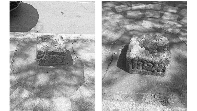
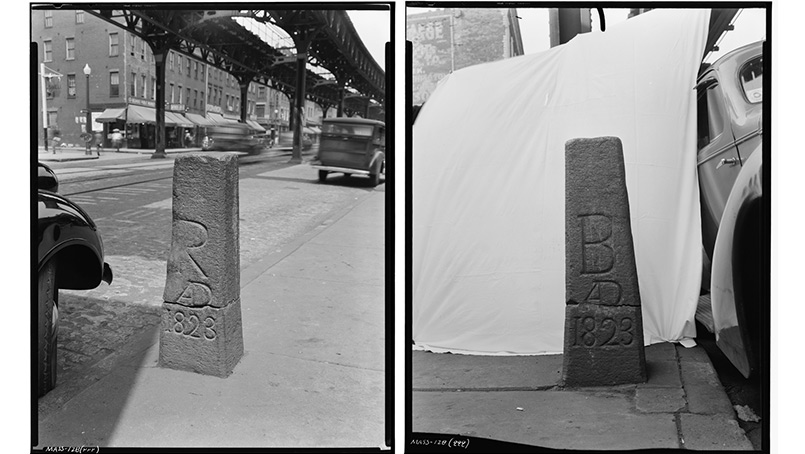
A little nub of a stone at 2000 Washington Street near Melnea Cass Boulevard with the date 1823 still marks a spot along the boundary between Boston and Roxbury. In an earlier posting , the existing 17th & 18th-century milestone markers were described. Another type of stone marker important to the history of Boston is the boundary marker. The photos were taken in 1940 by Frank O. Branzetti for the Historic American Building Survey. You can see the stone was broken even then.
In the early 19th century stone markers were installed to delineate the boundary between Boston and Roxbury. The remnant in the photograph is located in the sidewalk near the curb at approximately 2000 Washington Street near Melnea Cass Boulevard. The photographs from the Historic American Building Survey (HABS) show the full stone with the B for Boston and the R for Roxbury and the crack in the stone. In its current location, the stone has been turned 90 degrees, so that the carved sides are now parallel with the street. The inner side of the stone facing toward the sidewalk is in the upper left, and the side facing the street is in the upper right. The photographs from HABS show that in 1940 the carved surfaces were perpendicular to the street. Does anyone know where the top piece is today?
After Boston’s boundaries expanded through the annexation of surrounding towns in the late 19th century, markers that once marked the separation between Boston and the annexed towns are now well within the outer boundaries of Boston. Some of these markers are still in place. So you may come across a stone marker on a roadway or in a neighbor’s back yard. There is a marker that once indicated the separation between West Roxbury and Roxbury at the corner of School and Amory Street. When Roxbury joined Boston in 1868, the R was altered to a B.
Other stones can be seen in some of the references mentioned at this link: https://groups.google.com/forum/#!topic/westroxburyma/F-ZtwL5MUzI